Date: Sunday 29th January 2006
Duration: 7 hours (17 miles)
Another fresh January morning about 09:00 and it
was warm(2C), dry and more importantly not windy at all. I recommend that you
have a good ordnance survey map with you at this stage as we did. We left the
car at the bottom of Fairhill street in
Ballycastle and followed
the hill climb up towards Drumavoley and then turned right up past the cell
phone mast, at this point we discovered at the
fork
in the road earlier we had chosen left incorrectly but rather than back tracking
quite a steep climb we crossed the fields and met up with the track again and
walked the top path in Ballycastle
Forest. The map told us that we should go down to the road from here and
follow it until Breen Wood but as we prefer soft fields underfoot rather than
tarmac we choose to follow the route we had taken previously to climb Knocklayde
and when we reached the edge of the tree line we followed it south around the
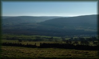
circumference of the mountain in the general direction of Breen Wood. As you can
see from the photos we made a wise choice, apart from the many fences to
straddle, the views were spectacular across the Antrim plateau. At this
stage we were down to t-shirts only as the sun was beating down so we stopped
for tea and grub.
We strolled on until we could see the entrance of
Breen Wood on the Glenshesk road
at which point we went straight down
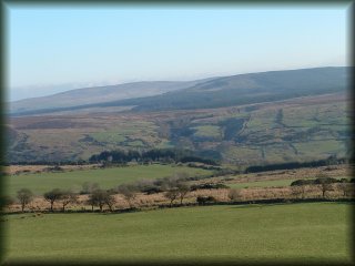
the mountainside. We walked up through Breen Wood, the only deciduous wood for
miles which in spring wields an impressive collage of flora. It's another steep
climb but once again the view backwards at Knocklayde is quite impressive. The
trail takes us over the summit of Bohilbreaga and Corvarrive and then down into
upper Glenshesk past McQuillan's Grave. The trail is reasonably well marked
although it trails the river for quite a bit making it easy to follow. It's
about 2pm so we stopped for lunch in an old ruin, sausages and bacon never
tasted so good. The trail follows the Glenshesk river back into the forest and
the view from this point is pretty cool as you can see. We finished up back on
the road that takes you back down into the village of Magherahoney, this is
important to know our phones didn't get signal up there so we had to walk
2 miles along the road before we got a signal to call for our lift home.
All in all a grand 17 mile hike that certainly
pushed it to the limit but what great views. Take good waterproofs and footwear
if you decide to do this one!
 the hill climb up towards Drumavoley and then turned right up past the cell
phone mast, at this point we discovered at the
the hill climb up towards Drumavoley and then turned right up past the cell
phone mast, at this point we discovered at the
 fork
in the road earlier we had chosen left incorrectly but rather than back tracking
quite a steep climb we crossed the fields and met up with the track again and
walked the top path in
fork
in the road earlier we had chosen left incorrectly but rather than back tracking
quite a steep climb we crossed the fields and met up with the track again and
walked the top path in 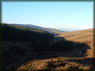 the mountainside. We walked up through Breen Wood, the only deciduous wood for
miles which in spring wields an impressive collage of flora. It's another steep
climb but once again the view backwards at Knocklayde is quite impressive. The
trail takes us over the summit of Bohilbreaga and Corvarrive and then down into
upper Glenshesk past McQuillan's Grave. The trail is reasonably well marked
although it trails the river for quite a bit making it easy to follow. It's
about 2pm so we stopped for lunch in an old ruin, sausages and bacon never
tasted so good. The trail follows the Glenshesk river back into the forest and
the view from this point is pretty cool as you can see. We finished up back on
the road that takes you back down into the village of Magherahoney, this is
important to know our phones didn't get signal up there so we had to walk
2 miles along the road before we got a signal to call for our lift home.
the mountainside. We walked up through Breen Wood, the only deciduous wood for
miles which in spring wields an impressive collage of flora. It's another steep
climb but once again the view backwards at Knocklayde is quite impressive. The
trail takes us over the summit of Bohilbreaga and Corvarrive and then down into
upper Glenshesk past McQuillan's Grave. The trail is reasonably well marked
although it trails the river for quite a bit making it easy to follow. It's
about 2pm so we stopped for lunch in an old ruin, sausages and bacon never
tasted so good. The trail follows the Glenshesk river back into the forest and
the view from this point is pretty cool as you can see. We finished up back on
the road that takes you back down into the village of Magherahoney, this is
important to know our phones didn't get signal up there so we had to walk
2 miles along the road before we got a signal to call for our lift home.